34°13′ N 5°42′ W TERRITORIAL SYSTEMS
Territories · Land · Geospatial Intelligence

Dr. Badr KHALLOUQ

State Engineer · PhD in Geography
Territorial Dynamics · Land Governance · Geospatial Technologies

State Engineer and PhD in Geography with over twelve years of experience at the intersection of territorial analysis, geographic information, land governance and spatial decision support. My work combines professional engineering practice, field-based territorial knowledge, scientific research and advanced geospatial technologies.

GIS & Spatial Analysis GeoAI Land Governance Cadastre Territorial Planning Remote Sensing Real Estate Valuation
Professional Profile

Engineering practice meets territorial research

A multidisciplinary profile combining territorial engineering, geographic knowledge, land governance, geospatial sciences and applied research.

Engineering

Engineering & Professional Practice

State Engineer in Urban Planning and Territorial Development with more than twelve years of professional experience. Since 2013, professional practice has included national cartographic operations, territorial and spatial analysis, geographic data production and validation, field investigations, geographic reference systems and geospatial decision support.
Research

Academic & Research Profile

PhD in Geography with research focused on territorial governance of agricultural collective lands in Morocco. Research interests connect land governance, territorial dynamics, rural transformations, public policy and geospatial approaches to territorial decision support.

Areas of Expertise

From geographic information to territorial decision-making

Expertise developed across professional engineering, applied research, teaching and territorial fieldwork.

01

GIS & Spatial Analysis

QGIS, ArcGIS, spatial analysis, cartographic modelling, multi-criteria analysis, spatial statistics and spatial data management.

02

Remote Sensing

Google Earth Engine, optical and radar imagery, land-use and land-cover classification, change detection and time-series analysis.

03

GeoAI & Machine Learning

Random Forest, XGBoost, SVM and spatial predictive modelling, including urban expansion simulation using SLEUTH, LCM and PLUS.

04

Cartography & Geodesy

Topographic mapping, GNSS, levelling, orthophotos, photogrammetry, map production and geospatial quality control.

05

Land Governance & Cadastre

Land information systems, cadastre, collective lands, melkisation, land governance, land valuation and rural land management.

06

Territorial Planning

Urban and territorial planning, land-use planning, territorial development, spatial analysis and territorial decision-support approaches.

Professional Experience

Territorial knowledge built through field and institutional practice

Professional experience combining national cartographic operations, territorial analysis, geospatial engineering, teaching and applied expertise.

2013 — Present

State Engineer

National Land Conservation, Cadastre and Cartography Agency (ANCFCC) · Department of Base Cartography

Professional activities include field missions across nearly 90% of the Moroccan territory, territorial and cartographic data collection and validation, national cartographic reference data operations, analysis of spatial and territorial dynamics, geographic reference systems and the development of geospatial tools for field data collection and quality control.

2025 — 2026

Teaching & Academic Supervision

Hassan II Agronomic and Veterinary Institute · Rabat

Teaching advanced GIS applied to territorial planning and supervising Master's-level work in Geospatial Sciences and Land Governance, including projects involving GeoAI, Machine Learning, Google Earth Engine, remote sensing and spatial predictive modelling.

Selected Activities

Consulting & Applied Expertise

Land · Environment · Territorial Studies · Real Estate Valuation

Additional professional activities include agricultural land prospecting and valuation, support for land and territorial studies, environmental impact assessments, and real estate valuation assignments involving land, residential, commercial, industrial and logistics assets.

Research & Publications

Understanding territorial transformations through spatial evidence

Research at the intersection of geography, land governance, territorial dynamics and geospatial modelling.

Peer-Reviewed Publication · 2025

Application of the SLEUTH Model for Land Use Prediction: Simulation of Urban Sprawl in the City of Meknes

Badr Khallouq et al.
E3S Web of Conferences · 2025
DOI · 10.1051/e3sconf/202567601001
Peer-Reviewed Publication · 2025

Urban Sprawl and Collective Land Vulnerability in Irrigated Perimeters: A Geospatial and Predictive Modeling Approach Using LCM in Sidi Kacem, Morocco

Badr Khallouq et al.
E3S Web of Conferences · 2025
DOI · 10.1051/e3sconf/202567602008
Research Manuscript

Collective Land Reform and Good Land Governance in Morocco: A Contextualized LGAF-Based Assessment of the Melkisation Policy in Sidi Kacem

Research addressing collective land reform, institutional land governance and the territorial implications of melkisation.

Research Manuscript

GIS-AHP Multi-Criteria Analysis for Mapping Agricultural Land Valorization Potential of Collective Farmlands in the Sidi Kacem Irrigated Perimeter, Morocco

GIS-based multi-criteria spatial assessment combining agricultural conditions, land characteristics, accessibility and AHP-based decision modelling.

Scientific Communication · 2026

FEZ GIS-Users' 2026 — 7th International Congress of GIS Users

Oral presentation accepted · Fez, Morocco · 7 October 2026.

Selected Geospatial Research

Three maps illustrating the core of my spatial research

A curated selection from a broader cartographic production developed through doctoral and applied research. These maps illustrate three complementary dimensions of territorial change in the Sidi Kacem region: urban expansion, collective-land vulnerability and agricultural land valorization potential.

The portfolio intentionally presents only three representative maps rather than the full cartographic corpus, allowing each visual to communicate a distinct research question, analytical method and territorial implication.
Urban Dynamics
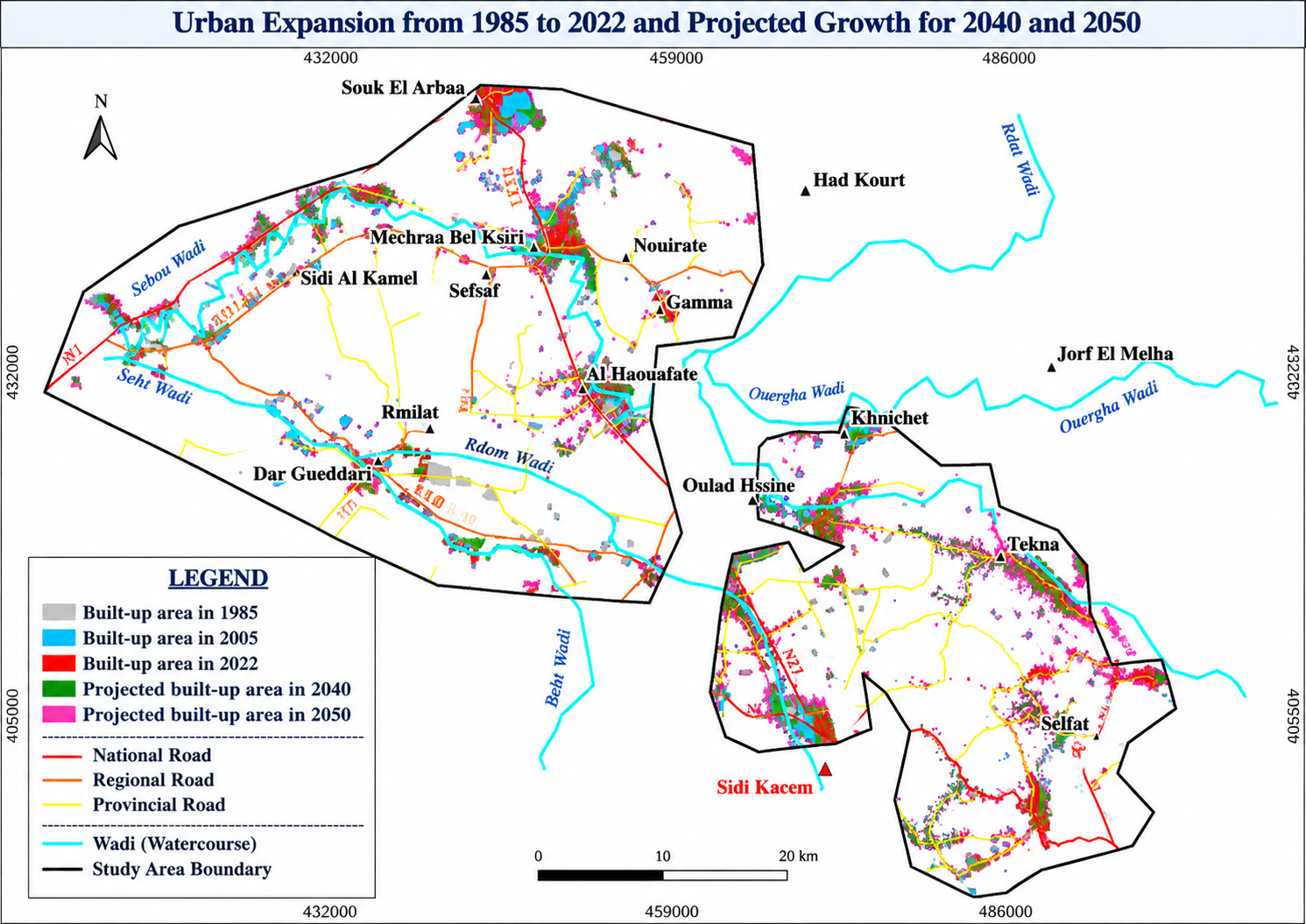
Urban expansion from 1985 to 2022 and projected growth for 2040 and 2050 in the Sidi Kacem study area
Selected Map · 01

Urban Expansion and Projected Growth · 1985–2050

Multi-temporal mapping of built-up expansion across the study area, combining observed urban development in 1985, 2005 and 2022 with projected built-up growth for 2040 and 2050.

The map highlights the spatial concentration of urbanization around existing settlements and major transport corridors, providing the spatial basis for assessing future pressure on agricultural and collective lands.

Research dimension Land-use change · Urban growth modelling · Spatial projection · Territorial dynamics
GIS Urban Sprawl 1985–2050 Predictive Modelling Sidi Kacem
View full map ↗
Click directly on the map for an enlarged viewer.
Land Vulnerability
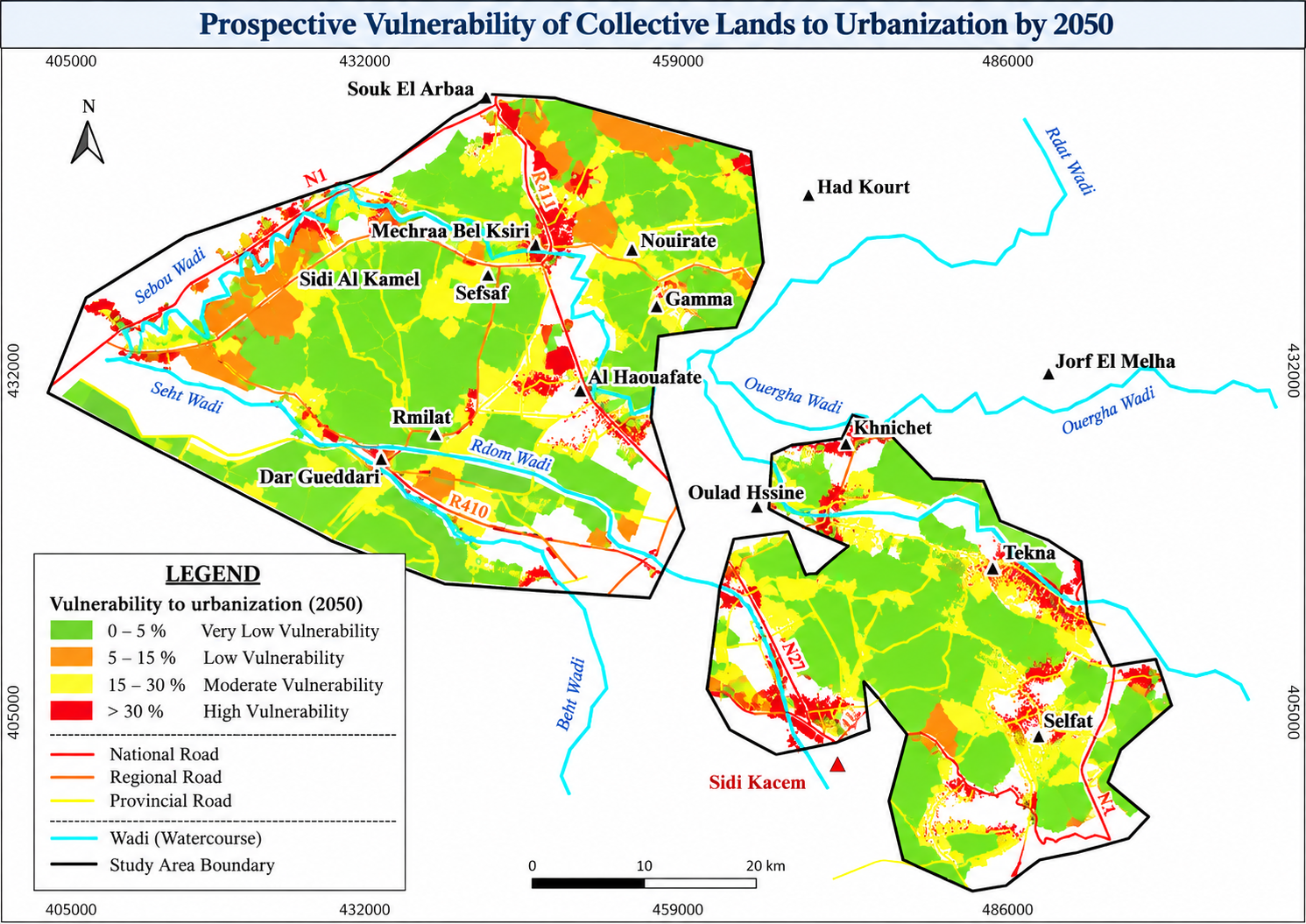
Prospective vulnerability of collective lands to urbanization by 2050 in the Sidi Kacem study area
Selected Map · 02

Prospective Vulnerability of Collective Lands to Urbanization · 2050

Prospective spatial assessment of collective-land exposure to urbanization by 2050. Vulnerability levels distinguish areas of very low, low, moderate and high prospective pressure.

The analysis identifies spatial hotspots where projected urban expansion may increasingly interact with collective farmland, supporting anticipatory land governance and territorial planning.

Research dimension Collective lands · Prospective vulnerability · Urbanization pressure · Land governance
Collective Lands 2050 Vulnerability Land Governance Spatial Planning
View full map ↗
Click directly on the map for an enlarged viewer.
GIS-AHP
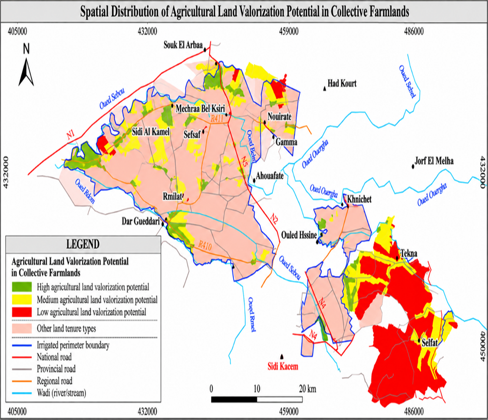
Spatial distribution of agricultural land valorization potential in collective farmlands in the Sidi Kacem irrigated perimeter
Selected Map · 03

Agricultural Land Valorization Potential in Collective Farmlands

Spatial representation of agricultural land valorization potential within collective farmlands of the Sidi Kacem irrigated perimeter, classified into low, medium and high potential.

The final index integrates irrigation accessibility, existing crops, soil characteristics, road accessibility and slope through a GIS-based multi-criteria framework supported by the Analytic Hierarchy Process (AHP).

Research dimension GIS-AHP · Multi-criteria decision analysis · Agricultural land · Spatial decision support
GIS-AHP MCDA Agricultural Land Collective Farmlands Valorization Potential
View full map ↗
Click directly on the map for an enlarged viewer.
Education & Knowledge Transfer

A multidisciplinary academic pathway

Academic training connecting geography, territorial planning, geospatial sciences, land governance and law.

Education

PhD in Geography

Sidi Mohamed Ben Abdellah University · Fez
2021 — 2026

State Engineering Degree in Urban Planning and Territorial Development

Higher School of Architecture and Building Professions – UPF · Fez
2022 — 2024

Specialised Master's Degree in Geospatial Sciences and Land Governance

Hassan II Agronomic and Veterinary Institute · Rabat
2018 — 2020

Bachelor's Degree in French Law

Mohammed V University · Rabat
2018 — 2019

Professional Bachelor's Degree in GIS and Spatial Management

Ibn Tofail University · Kenitra
2017 — 2018

Teaching & Research Supervision

Advanced GIS for Territorial Planning

Spatial analysis methods and applied territorial analysis

Master's Research Supervision

Geospatial Sciences and Land Governance

GeoAI & Spatial Modelling

Machine Learning · Google Earth Engine · Remote Sensing · Predictive Modelling

Research Themes

Territorial dynamics · Land governance · Property valuation · Geospatial decision support
Contact

Let’s connect

For academic collaboration, research, teaching, geospatial projects, territorial studies and professional enquiries, you can contact me directly or connect through my professional and scientific profiles.